THEMIS & 4.7
Question: Does the THEMIS team release
their images pre-aligned, north up?
I thought so, until I applied my proven
measuring technique to this visible light image.
One might notice north is not notated like
That should have been my first clue to
look more closely than I apparently did.
This is one of the disadvantages to
working alone. There’s no one asking me questions or challenging my ideas.
That said… J
All I can say for sure right now is that
the image is oriented precisely 2.35 or (4.7 / 2) degrees off
Cydonia north as established by my geometry map.
Let me show you what 2.35 degrees
looks like and how I figured this out, meaning aside.
I know from my geometry work that
the D&M’s axis of symmetry is precisely 10.5 degrees off Cydonia
north.
Also note precisely where a Cydonia north line exits the top right corner of FOM. For further explanation of why that’s important, see this page.
(This
image created from my personal geometry .psd file. )
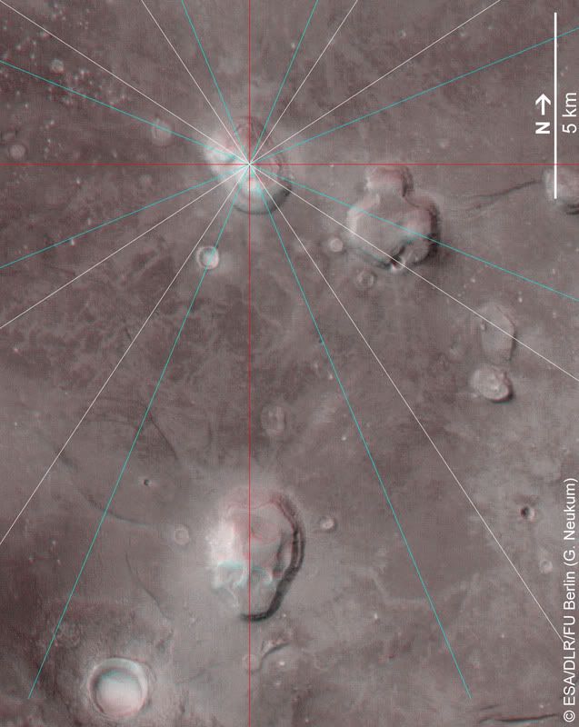
Here is another frame of reference for Cydonia north
using my geometry map. In this image, simply note where the north line penetrates
the south ‘crater’ when the line is situated in the middle of the Fort’s
‘alignment circle’.
(This image created from my personal geometry .psd file.)

I thought I knew from
Notice
ESA released the
following image with north notated, but pointing straight right.
Why?
In the following images, I simply rotated
Rotate that image 4.7 and there you have it.

Or so I thought.
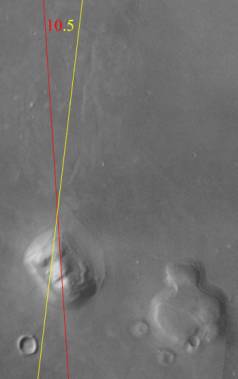
Now, take a look at the THEMIS image in
question, #
V12445004. Something pulled me
towards this image last night.

Here’s what happened when I dropped in a perfect
vertical line.

That looks pretty close to this, doesn’t it?

Well once again, the key is in the geometry. It all
begins with one precise 60 degrees angle.
Assuming Themis oriented their image north
up and I’m right about Cydonia north being offset from true north by 4.7
degrees, these are the steps I should have to take in order to make this work.
Step 1. Rotate, their image 4.7 degrees.
Ok, that looks good…
(Image
rotated 4.7 degrees.)

Now, all I should have to do is copy and
paste two north lines, rotate one of them 10.5 degrees and the other one
-49.5 degrees.
Theoretically, that’s all I should have to
do to make the geometry fit.
The geometry should just ‘snap’ into place. It
doesn’t.
(Image
rotated 4.7 degrees)

So, guess what the magic number is to make
everything ‘snap’ together…

The magic number is 2.35 degrees.
All I had to do was rotate the image back –2.35
degrees and everything fell into place as you can plainly see above.
The biggest question I have right now is about
this particular image.

Who oriented it and why? The ‘blockies’ do
follow a perfect vertical line.
This is the image that sparked this whole
business of 4.7…

Along with this image…

There is something very significant about
all of this.
Hopefully some answers will surface in the
very near future.
The answer may actually be that Cydonia’s
north is offset 2.35 off north.
Here’s what the geometry looks like on
It doesn’t work as ‘tightly’ as the THEMIS
images do, but it seems to work good enough.
I think I may have given up too easily.

The only real problem I have with the
above work is how the D&M’s left arm doesn’t appear to fall on the same
side of the line as it does on the THEMIS data.
Other than that, on second thought, it works
very well.
So, the moral of the story…
Keep going! J